Archive for the 'Hiking' Category

h1

Vermont Country

Friday, June 27th, 2008

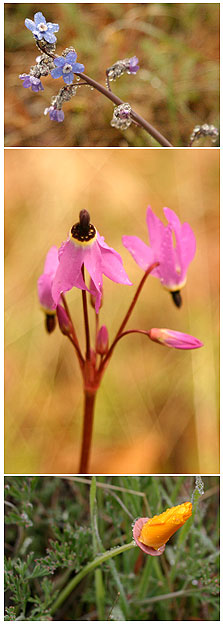
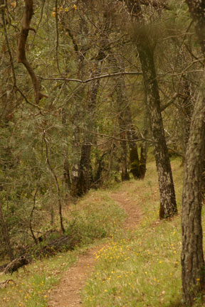
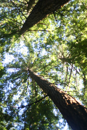
We drove through the back roads of Vermont, spotting numerous farms and covered bridges among the rolling hills. In the Green Mountains National Forest we walked the Robert Frost Trail, a 1.2 mile loop with Robert Frost poems posted along the way.

It began raining on us as we were finishing up the trail. It rained as we drove, looking for some lunch. We passed through town after town with no food in sight. Finally, we spotted a roadside grill. We dodged the rain to only discover that they didn’t have any power. We drove into Brandon and found a pizza place. Shortly after ordering, they lost power as well. By now, we were past being hungry. Eventually, we found food further down the road, but by then it was dinner!

Our Vermont lodging consisted of the nice Churchill House Inn Bed and Breakfast outside Brandon, VT. We were served delicious omelets, croissants and fruit for breakfast.

churchillhouse.jpg

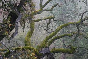
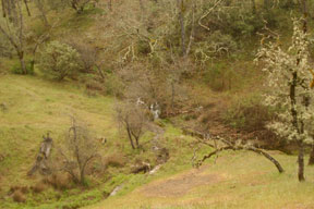
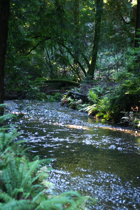
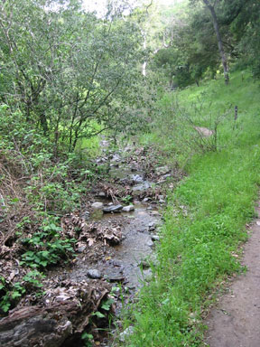
A trail into the Green Mountains begins right near the house. We walked the path that followed the stream for a short while but turned back due to the dreaded mosquitoes. It was beautiful and we would have gone longer if we had been more prepared for the mosquitoes.

greenmountains.jpg

h1

In Nature

Saturday, March 29th, 2008

It’s spring, the wildflowers are in bloom and we are forcing our children to take hikes. We are mean parents!

Take a look at what we saw at Henry W. Coe State Park:

coe1.jpg

coe2.jpg

coeflowers.jpg

coe3.jpg

h1

Soak Up the Sun

Saturday, February 9th, 2008

I planned to bathe the dogs yesterday but I flung it aside for some Vitamin D therapy.

I met with my wonderful hiking group yesterday and we climbed the hills of Redwood City in search of the physical location of the large white cross. With all the recent mud, we decided to stay off the trails and hike on the streets. Redwood City has hills, though, so we were able to get some exercise. Afterwards we returned to one of the ladies’ house. It was 65 and beautiful. We all needed our vitamin D so we sat in her backyard and soaked up the sun. She even served us lunch! Ahhhh…. Then, last night I noticed I had a slight burn from sitting in the sun. Jackie said, “First burn of the year…in February!”

Ah, gotta love California.

h1

Muir Woods National Monument

Monday, December 31st, 2007

Looking at the girl’s tag log books of national parks and monuments they have visited, I realized they have never been to Muir Woods National Monument. With it being so close to our house, we had to rectify the situation.

While Mike’s parents and sister were visiting we took one day to visit Muir Woods National Monument. Muir Woods offers a nice location for seeing an old growth stand of coast redwood trees. The paved path, which wanders along a river, kept us sheltered and gave us great views of these large trees.

mwriver.jpg

mwtrees.jpg

h1

Hiking with Giant Sequoias

Tuesday, December 4th, 2007

With some days off school in the fall, we took the opportunity to visit friends in Hanford and take the girls to Sequoia National Park and King’s Canyon National Park. The main features of the trip were seeing the Giant Sequoias and hiking.

One the first day in Sequoia NP we climbed to the took of Moro Rock (a steep 1/4 mile staircase climbs over 300′ (91.4 meters) to the summit of this granite dome), hiked to the General Sherman Tree (274.9′ (83.8 meters) tall, and 102.6′ (31.3 meters) in circumference at its base), hiked on the Congress Trail (a 2-mile paved trail through the heart of the sequoia forest, and hiked the Big Trees trail (a 1.2-mile loop around Round Meadow.)

On the second day we visited King’s Canyon NP. We hiked the Grant Grove trail to see the General Sherman tree. For a longer hike, we hiked along the ridge in the Grant Grove area.
We ran into a problem with food as it was fall and most places to acquire food where closed. Our lunch on the first day consisted of food we had acquired in Hanford from our friends.

h1

The Mighty Mississippi

Thursday, July 19th, 2007

The acclaimed headwaters of the Mississippi start at Lake Itasca so we took a short drive north with my brother’s family to visit Itasca State Park.

We discovered, though, a great deal of controversy on the subject of the true headwater or starting point of the Mississippi River. Wikipedia’s article on Lake Itasca tells the story: Henry Schoolcraft identified Lake Itasca as the river’s source in 1832. He had been part of a previous expedition in 1820 led by General Lewis Cass that had named nearby Cass Lake (which is downstream from Itasca) as the source of the river…The western arm of the lake is fed by two small streams on its south end. Nicolett Creek, which is considered too small to be considered as the headwaters, starts in a nearby spring. Another small stream leads into Itasca from Elk Lake, which in turn is fed by two other streams. In1887 Williard Glazier promoted a campaign to consider Elk Lake, which he called Glazier Lake, as the true source of the Mississippi. These streams, however, are generally considered too small to be categorized as the headwaters of the river. The decision was made by Jacob V. Brower, a land surveyor and president of the Minnesota Historical Society, who after spending five months exploring the lakes ruled that the lakes and streams further south of Lake Itasca were not the true source of the Mississippi.

This led us all to wonder what really did constitute the beginnings of a river. Was it the first trickle of water? Was it the earliest lake from which is originates? Or something else? And we also wondered when rivers join, how it is decided which river it is at that point.

Regardless, the headwaters are now officially located at Lake Itasca at a very obvious point. It is obvious because in the 1930’s the Civilian Conservation Corps actually moved the channel of the Mississippi as it emerged from the lake to make a more pleasant experience for visitors. They drained the swamp, dug the new channel and installed a man-made rock barrier to create rapids from the lake to the channel. Now tourists who visit the site wade across the rock barrier.

mississippi.jpg

h1

A Sign of Spring

Wednesday, July 11th, 2007

1 sign of Spring: Our family visits the Sunol Regional Wilderness for our annual hike there.

For 9 months of the year we avoid hiking in the east bay because it is hot, the grass is brown and the views are uninspiring. But the spring rains bring a different story. The Sunol area livens with abundant wildflowers, flowing creeks and wildlife.

sunolcreek.jpg

One trail, Indian Joe Creek, is especially beautiful and leads to an area of large, jumbled rocks. The girls love to scramble, climb and imagine at these rocks.

sunolrocks.jpg

April 2007

h1

Climbing the Dome

Thursday, October 26th, 2006

On our list of things to do was to climb the dome at Yosemite. Since Half Dome is closed right now, we chose a smaller dome, Lembert Dome. But with the extra mileage Jackie and I sustained (see next post) we scaled down to the even smaller Pothole Dome.

Jennifer enjoyed scrambling up the dome.

potholedome.jpg

From up top we had wonderful views of Tuolumne Meadows like this one:

tuolmeadows.jpg

h1

The Adventures of Lyell Canyon

Thursday, October 26th, 2006

October 24, 2006

The most adventurous portion of our vacation involved two incidents in Lyell Canyon near the Tuolumne Meadows Lodge.

As per the map we had in hand, we hiked across the Dana Fork and then the Lyell Fork of the Tuolumne River. After crossing the Lyell Fork, we headed on the path along the river with the river on our left side. Beautiful views of the river, fall foliage and the granite boulders in the area greeted us at every turn.

lyellfork.jpg

It was too much for the girls so we stopped in one of these areas along the river and let them climb, skip and hop. Here, among the boulders and calm, cold icy stream the first incident happened. We called the girls to continue on the hike, but as Jennifer was less than a few feet from the shoreline, she slipped on a log. She fell, caught herself, but landed in the water. Breaking the thin sheet of ice, she ended up waist deep in the stream. Dressed in jeans for this warm October day, she was cold, shocked and unhappy. Mike volunteered to hike her back to the van. Thankfully, we had clean, fresh clothes in the van. Mike reported that her attitude did a 180 degree change when she feel in the ice…from not wanting to leave to hating the place…then when she got dried back 180 degrees to loving the place.

Meanwhile Jackie and I continued the hike to the next stream, Rafferty Creek. The creek was dry so we immediately turned around and went back. But as we hiked back, we noticed things were not the same. The Lyell Fork was farther back and the sights didn’t seem completely familiar. We came to a sign we hadn’t seen previously. There were three directions. We choose the direction along the river and continued onward. When we met another sign we hadn’t seen beforehand we knew we were on the wrong path. It confused us though because the river was supposed to be on our right as we were heading back. It was on our right, but things didn’t look the same. We backtracked to the first unfamiliar sign then tried the other path toward the river. Thankfully, this got us “unlost.” We found one of the bridges we had crossed earlier over the Lyell Fork and continued back to the van. We were 1/2 hour late and starving. Fortunately, my wise husband had gone to the van and brought lunch back to a great picnic spot.

How did we get temporarily lost? A look at the map made me realize what had gone wrong. When we turned after crossing the Lyell Fork, we headed along the river BUT we weren’t really on the path. We were on a man-made path that was so well used we thought it was the real path. So, when Jackie and I turned around, we didn’t find the man-made path, we found the real path. So that’s why things didn’t look the same at first and that’s why we came to an unfamiliar sign and that’s why we went a little farther than we should have gone. On the bright side, we now know about a great little loop trail there!

I greatly appreciated how Jackie controlled herself and her emotions while we were temporarily lost. It is scary to be “lost” but it really helps if you can just think things through. I would say we were never really lost because we could have always backtracked our steps and we had firm plans for what to do if we got to spot X or a sign that said Y. We were on an unexpected, extended adventure.

h1

Devil's Postpile

Thursday, October 26th, 2006

October 23, 2006.

In the early morning we awoke and drove to Devil’s Postpile. We appeared to be the first to arrive at the national monument, but it never did see many visitors at all.

As it was off-season, we drove into the park. From the parking lot, we hiked the easy trail to the postpile. We could clearly see the columnar basalt. We had seen pictures of the straight columns but were surprised to see the bent columns.

devilpostpile.jpg

A steeper climb enabled us to go to the top of the postpile. From here we could see the columns from their tops, stacked next to each other. Finally, we walked on to the 101-foot high Rainbow Falls. This extra few miles took a toll on the girls. I was very grateful when we reached the falls and enjoyed a snack as moods changed dramatically.